Wednesday, August 29, 2007
sorry about no posts
The internet connection here is awful and I have not been able to get any pictures uploaded so keep checking back and hopefully ill get a solid connection one of these days
Monday, August 27, 2007
Gooseberry Mesa
Howie and I had done this ride about a year and half ago when we were in St George and knew that this ride lived up to its hype and really thought the other guys should get a chance to ride it. It was a pretty long ride to get there, about 2.5 hours but part of that drive was through Zion National Park, slow but worth it for the amazing views. We also found out a negative about driving a dually, there is a narrow tunnel in the park so they make any "oversized" vehicle pay an extra $15 because the rangers have to stop traffic and turn the tunnel into a one way for a mile and half. The kicker is they have so many "oversized" vehicles, they are pretty much stopping traffic all day long, but what the heck. Howie and I had approached the trailhead from the other side last time so we were not sure how the first 6 miles on dirt road were gonna go. The Beast had no problem but it was a credit to Scott's driving that he was able to get the rental minivan up through the crummy dirt road. The GPS came in handy figuring out which right to take out to the trailhead off the "main" dirt road since there was no sign at this point, so another 3 miles of fun and we got on the bikes for the last mile of really bad road to the trailhead. We headed out on the southrim trail through a mix of sandy dirt trail and white dots painted on slickrock, large masses of more or less sandstone. The name slickrock is a misnomer as your tires really stick to it like glue allowing for you to go up some seemingly impossible short steep sections. I am however afraid to look at my poor Nevegals as they wear quickly on dirt and I can't imagine what this stuff was doing to them.
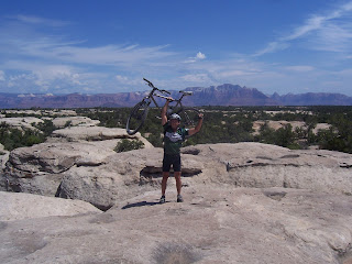
Here's Ho on top of some of the slickrock formation with the Zion in the background. We continued like this for a few miles, not gaining anything in overall altitude but all the short ups really start to add up. There is also almost no shade and the sun beat on us pretty much all day. It wasn't too hot by Gooseberry standards, high 80's to low 90's but still hot.
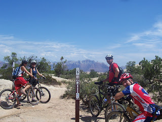
We ran into a couple cuties, locals from down in St George, so we stopped to chat with them for a bit.
After about 4 miles you hit the first of the rim view points, a southern view that includes highway 59 and the town of Huricane down in the distance.
After another mile or so you make it out to the point with at least a 270 degree view including the one below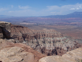
The ride out to the point was an out and back then after a bit of memory searching howie and I remembered that we took a degraded gravel road for a little bit then picked up the Yellow trail, a bit more technical than the first section, but similar slickrock. We crossed back over the road and caught the northrim trail
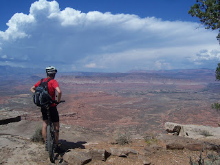
We could see the storm clouds starting to form in the mountains and began to get a little worried as the access roads turns to muddy impassible soup when they get much rain. We cut the ride a little short taking the most direct route back to the vehicles, but still a great ride. We were hustling to get things packed up and on the road when up drove two pretty clueless chicks drive up in a sporty little car, not sure how they made it back that far, but Craig had to go over and start chatting them up and then was a little upset when we were all ready to go, yelling at him to get a move on, and nobody had put his bike in the van. They took our suggestion and headed out too. We took the shorter, easier route back to pavement crossing our fingers the light rain didnt get any harder before we reached pavement. All went well and the route out left us with a longer mileage distance and no views of Zion, but it was the safest choice.

Here's Ho on top of some of the slickrock formation with the Zion in the background. We continued like this for a few miles, not gaining anything in overall altitude but all the short ups really start to add up. There is also almost no shade and the sun beat on us pretty much all day. It wasn't too hot by Gooseberry standards, high 80's to low 90's but still hot.

We ran into a couple cuties, locals from down in St George, so we stopped to chat with them for a bit.
After about 4 miles you hit the first of the rim view points, a southern view that includes highway 59 and the town of Huricane down in the distance.
After another mile or so you make it out to the point with at least a 270 degree view including the one below

The ride out to the point was an out and back then after a bit of memory searching howie and I remembered that we took a degraded gravel road for a little bit then picked up the Yellow trail, a bit more technical than the first section, but similar slickrock. We crossed back over the road and caught the northrim trail

We could see the storm clouds starting to form in the mountains and began to get a little worried as the access roads turns to muddy impassible soup when they get much rain. We cut the ride a little short taking the most direct route back to the vehicles, but still a great ride. We were hustling to get things packed up and on the road when up drove two pretty clueless chicks drive up in a sporty little car, not sure how they made it back that far, but Craig had to go over and start chatting them up and then was a little upset when we were all ready to go, yelling at him to get a move on, and nobody had put his bike in the van. They took our suggestion and headed out too. We took the shorter, easier route back to pavement crossing our fingers the light rain didnt get any harder before we reached pavement. All went well and the route out left us with a longer mileage distance and no views of Zion, but it was the safest choice.
Sunday, August 26, 2007


 sorry for the day delay on the blog but we were having internet connection issues last evening. Our first "real" ride down south was a concoction of a couple of rides from the guide books. It was in the red canyon area, near Bryce Canyon, similar red rock formations. These are also the canyons that Butch Cassidy and his gang were supposed to have hid out in between train robberies in the wild west. It is an amazing landscape, totally different than anything we have ridden in before. The trail tred was from hard packed to sandy, lots of shorter ups and downs. The whole ride was between 7200 and 8000 feet but it was some where in the neighborhood of 2500 feet of climbing. The first part of the ride was more or less up Cassidy trail to Losse Canyon trail. There was a nice view point of the canyon from above before we actually rode down though it. there was bit of gravel road from the base of Lossee to the base of Castro then up the ATV trail through Castro. The track was nothing exciting, basically a loose double track along the wash at the base of the canyon, then down through it, then back on the other side. We passed a few groups of ATV's going the other way but they were quite curious, no issues at alls. The ATV trail went the left and the single track headed up the canyon to the right which we took then bending around eventually hooking back up at the top of Lossee canyon. They built a more technical trail that sort of criss crossed the cassidy trail back which we took, alot of fun. Back to the car was about 24 miles, and being out in the sun for 5 hours really took it out of us.
We rode Gooseberry mesa today, but i dont have the pictures on the computer yet, so that will have to wait till tomorrow.
Friday, August 24, 2007
A Western Trip First

Well first an update from yesterday, the
 We packed up this morning, the first time we really packed up the RV after having “lived” in it. It actually went pretty well, we left within a half hour of when we had planned to. I was a little apprehensive about the drive as we had to head down through
We found the “Hitchin’ Post” RV park pretty easily, just on the edge of the thriving metropolis of Panguitch. Its really not much to look at, but we got the RV in pretty easily and hooked up and there was nice spot to set up the “Swamp” tent for the

It was the first time we set out on a ride that we purposely knew we would be heading back to the vehicle in the dark. Howie and I both brought our night riding lights and most of the ride back was on gravel road so no big deal. We got there a bit past what would probably have been prime photography time, but the sunset was pretty amazing with about a 300 degree view. When we got back to the truck, we could see a wildfire down in the valley burning, pretty amazing as well. By the time we got back to town it was after 10 and everything but one gas station/ mini mart sorta place. We picked up a couple of candy bars and some bread. We had some smoked tuna in packets in the RV so we made up some tuna fish salad on toast with cheese
Wednesday, August 22, 2007
South Skyline trail


Well we finally headed up to the Ogden area to ride one of the skyline trails. We headed down to Salt Lake City, then up I15 to Ogden, then up Ogden Canyon to Pineview Reservoir. I was still feeling the effects of yesterday's ride, more mental than physical but my legs were less than fresh as well. I quickly found myself breaking our first rule of riding with our group, no whining, so I shut up and got ready for the ride. We had the route downloaded on the gps from a website so at least route finding should be easy. We found the start of the trail, a silly steep 30 yards or so, not a good omen. But the grade quickly leveled out to a more reasonable pitch that I could keep a good spin going at 1-3 or so. The two miles covered 800 feet, more than reasonable as we have determined over our trips that a grade of about 500 feet per mile is about all that we want to climb on a sustained basis. For those of you that ride Rothrock, thats about the over all pitch of lower Sassafrass but throw in the elevation and its tough. I found myself needing to stop at that point and eat a bar. Another mile of slightly more pitch and we were at the first big overview of the Ogden valley, like a "agrarian quilt." We had about a half mile of up and down then the sustained climb started again, topping out at 8000 feet, 3000 feet higher than when we started. We had the opportunity to take a 2 mile out and back to Lewis Peak, about 200 more feet of climbing, but Pooh was "finished with climbing" so we passed, because it is All About Pooh around here. There was also a minor issue about timing as we need to pick up Ho at the airport at about 7. We had slight climb to the final peak before we headed down. The first section was down along the ridge, nice views but a rather loose tread. From there it got steeper and stayed loose. There were some opportunities to catch some air over roots but without any knowledge of the trail and what the landings might be, I took them rather conservatively. We also ran into a couple of hikers on their way up and soon realized why as there was a major trail head parking at the end of the section. We felt a little jiped as we didnt seem to get enough downhill for all the stinkin climbing we did. From that trail head we headed down an old double track that was probably more single than double. Pooh was first down, stopped at one point and yelled back at me something unintelligible so I slowed down a bit and quickly realized he was trying to warn me about a dead deer laying right across the trail, YUCK! We got howie stopped in time and around it. Some more double track some of which was quite rutted then we hit pavement. A couple miles on pavement and found the pineview res. trail. It was sort of an overgrown rail trail with some wide bridges that ran around the edge of the water back towards the trail head, nothing to write home about about but better than the alternative major highway. It put us back on the highway at one point and Pooh decided to just ride pavement back while howie and I took the mowed path that kind of continued around the water. It ran us into a boat launch area about a half mile from the the truck and we took a look for its continuation across the parking lot. We found two trails and took the better looking of the two but that just took us down to the water. The reservoir was kind of low so we decided to just ride the edge which seemed reasonably firm around to the truck. At one point near the end, we found out later that Pooh was able to see us, we had to hike a little bit as the water went around a little point. Pooh apparently found great humor in this and got some strange looks from others in the lot as, apparently, he was about crying he was laughing so hard. We had run out of recovery drink mix after yesterday so all we had was cokes. It was about 4 or so and we were starving so we stopped at some Italian fast food place in Ogden on our way back to the interstate and had a "snack" of pizza. We were in good shape to hit the Radio Shack, I need some pieces parts for the video camera set up, and then make it to the airport by 7 to pick up Ho. That was before we hit the back up due to a lane closure. We got a call from Ho that he was on the ground and we let him know we would be a bit late. We got up to the next exit and decided to take surface roads around for a bit and between my maps and Pooh's gps we got around and back to the interstate before the exit for the airport. We found Ho pretty easily but were tempted to see if any of the nice looking ladies needed a ride instead. Back on the road, we stopped at Radio Shack, english was not the first sales guys primary language, he was watching soccer on the dish. I found what I need on my own and got outta there pretty quickly. Back on the interstate headed for camp, we decided to hit the mexican place for dinner then a quick stop at the grocery for breakfast stuff and back to show Ho his home away from home for the next little bit. We got ahold of the folks from Harrisburg and set a time for breakfast in the morning.
Tuesday, August 21, 2007
Mt Baldy Etc
Well todays ride was written up in two different guide books/ websites and was pretty close to home so we decided to do it. The ride started from Jeremy Ranch, just across I-80 from Park City. We headed down the East Canyon road through cattle grazing territory for about 4 miles to the trail head for the Mormon Pioneer trail. This was part of the route the original mormons took when they came to the Salt Lake City area. It was quite a nice trail, about 4 miles, 1400 feet of climbing up a dry creek bed. The trail surface for the most part was hardpacked. There was a nice ladder ramp over a 2 foot deadfall and an alternate log ride line that we didnt take about half way up. Pooh bear stopped and said he saw a couple moose that move off into the brush. I started to chalk it up to hallucinations again but as we stood there and watched this downed tree he insisted was one of the moose, it moved. We saw his tail and ears move, then finally got a good view of her head and did confirm it was moose, very cool. We hit the intersection of the Great Western Trail and made a bit of a navigational miscue.  There was a giant sign for the Great Western Trail Head right next to a nice single track so we assumed that was the trail we wanted. The guide book's elevation profile showed it as a climb out of this intersection but this went down, so after about a mile and 400 feet of decent, we stopped and realized we screwed up. So back up we went, bonus mileage we call it. We found the right trailhead blocked by a couple of phone service trucks up a short gravel road. So up we went. Pooh bear had the climbing legs and I think cleaned the 400 foot climb. Howie road a fair amount of it and walked more than I rode. We got to the top and it was quite a spectacular view although there was a fair amount of haze in the distance towards Salt Lake. After a stop for the required pictures
  we headed down towards our next climb, down 400 feet then back up 400. We had a few fits and starts of climbs that didn't materialize but we finally got to it. The guide book said this would be a hike-a-bike and it was. The trail was very rutted down the middle and very steep. If anybody had legs of steel they were still screwed as any ridable areas were full of baby head sized rocks. We walked up about 300 of the feet then hit a ridable section then a last push up to Mt Baldy. As you might surmise, it was free of any trees or for that mater shrubs. It provided a 360 degree vista, pretty spectacular.
  We had a fairly loose decent before another bit of climbing. Up and down and across bench cuts we went on a fairly loose trail. We had a bit of discussion at one of the trail intersections, but ended up making the correct choice. We arrived at the final decent, a bit of double track then some switch backing single track and benchcut run above the Jeremy Ranch development and back at the truck, 5 hours, 21 miles and 4000 feet of climbing later.
 There was a giant sign for the Great Western Trail Head right next to a nice single track so we assumed that was the trail we wanted. The guide book's elevation profile showed it as a climb out of this intersection but this went down, so after about a mile and 400 feet of decent, we stopped and realized we screwed up. So back up we went, bonus mileage we call it. We found the right trailhead blocked by a couple of phone service trucks up a short gravel road. So up we went. Pooh bear had the climbing legs and I think cleaned the 400 foot climb. Howie road a fair amount of it and walked more than I rode. We got to the top and it was quite a spectacular view although there was a fair amount of haze in the distance towards Salt Lake. After a stop for the required pictures
  we headed down towards our next climb, down 400 feet then back up 400. We had a few fits and starts of climbs that didn't materialize but we finally got to it. The guide book said this would be a hike-a-bike and it was. The trail was very rutted down the middle and very steep. If anybody had legs of steel they were still screwed as any ridable areas were full of baby head sized rocks. We walked up about 300 of the feet then hit a ridable section then a last push up to Mt Baldy. As you might surmise, it was free of any trees or for that mater shrubs. It provided a 360 degree vista, pretty spectacular.
  We had a fairly loose decent before another bit of climbing. Up and down and across bench cuts we went on a fairly loose trail. We had a bit of discussion at one of the trail intersections, but ended up making the correct choice. We arrived at the final decent, a bit of double track then some switch backing single track and benchcut run above the Jeremy Ranch development and back at the truck, 5 hours, 21 miles and 4000 feet of climbing later.
Monday, August 20, 2007
Return to Bench Creek
Well first, apologizes for no pictures. I arrived back at the bench creek trailhead after being turned away by weather last time, but with a new partner for the ride. After the epic yesterday, howie decided to give his back a rest, it was not bothering him but he did not want to push it. Pooh and I did the few mile paved road section to the dirt trailhead without issue. We headed up along Bench Creek, staring out as a nice buff single track. As the ride description told us, we ran into a number of relatively short technical ups in between the the buff sections on our way up the canyon. Pooh tried and made more of them than myself but still had to walk a bit. It was a fairly constant grade up, more or less middle ring near the upper end of the cassette. After about 5 miles and 1500 feet or so of climbing we hit the reroute the forest service put in a few years ago to keep the trail off of private ground. It was quite steep, I walked the majority of it but Pooh valiantly rode a good portion. at the top we crossed over a dirt road then onto the intersection with Camp Hollow trail. Down we went through a few meadows then along the creek, lots of fun. We hit a short up, we both were struggling a bit with it when I said something and he was glad I did because he thought it was just him. Still cant figure it out, it didnt seem too steep. After that we had a bit more down and we were at the intersection with the Little south fork that we had come down a couple times previously, but no sheep dogs. I forgot that David's mud puddle was coming up and Pooh saw it too late, he got slowed down enough to keep from going over the bars like David, but sunk his wheels and one foot in deep to the point he had a heck of a time pulling them out. The rest of the trip down was pretty uneventful, a few of the rocky sections caught him off guard but all in all a great ride. We hit Agony hill and Pooh cleaned it, I slid out on a rock about 20 yards from the top of the steep section, but continued to ride it up. A rocky downhill and some jeep trail and we were back at the truck. It took us about 3 hours to do the 17.5 miles and 2600 feet of climbing. It felt a little wimpy but 10.5 hours over 2 days riding isnt too bad.
Back at camp, howie had done laundry and we headed first to the hardware store then to the grocery store as Pooh went fishing. Joanne happened to call howie as we were checking out at the hardware store, he mentioned where he was and she got scared until he told her he was there with me. BBQ chicken and burgers were on the menu for the next couple nites. Pooh made it back claiming to have caught a few more but again with no proof what so ever. Currently we are watching the last of the Family Guy first season DVD's I brought along. We still havent figured out what we are gonna ride tomorrow but will tomorrow morning.
Back at camp, howie had done laundry and we headed first to the hardware store then to the grocery store as Pooh went fishing. Joanne happened to call howie as we were checking out at the hardware store, he mentioned where he was and she got scared until he told her he was there with me. BBQ chicken and burgers were on the menu for the next couple nites. Pooh made it back claiming to have caught a few more but again with no proof what so ever. Currently we are watching the last of the Family Guy first season DVD's I brought along. We still havent figured out what we are gonna ride tomorrow but will tomorrow morning.
Subscribe to:
Posts (Atom)